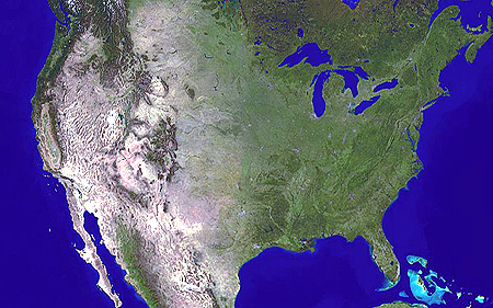
Geografi ; klima ; demografi ; historie ; ophørte fredsbevægelser ; ophørte politiske partier ; ophørte sociale bevægelser ; krige ; kultur ; biblioteker ; kunst ; film; musik ; musikorganisationer ; folkemusik ; jazz ; pop ; rock ; musiklitteratur ; politik: indenrigspolitik ; udenrigspolitik ; præsidenter ; regering ; lovgivende forsamling ; valg ; militær ; kernevåben ; efterretningstjenester ; aktuelle politiske partier 2010 ; aktuelle fredsbevægelser ; militærnægterorganisationer ; religion ; aktuelle sociale bevægelser ; sociale forhold ; uddannelse ; universiteter ; økonomi ; våbenhandel.

Amerikansk natur

American nature

Milieu naturels États-Unis

Entorno natural de los EE.UU.

Amerikanischen Natur

Floder:
Natur, klima. Biodiversitet. Fauna og flora: Botaniske haver ; Fisk. Fugle. Koralrev. Vådområder.
Nature, climate. Flora and fauna: Botanical gardens. Fish. Birds. Coral reefs. Wetlands
Flore et faune: Poissons. Oiseaux. Les récifs coralliens. Les zones humides.
Flora y fauna: Fish. Pájaros. Los arrecifes de coral. Los humedales.
Natur, Klima. Flora und Fauna: Botanische Gärten. Fisch. Vögeln. Korallenriffe. Feuchtgebiet, Feuchtbiotop.
Fugle:
North American Important Bird Areas: A Directory of 150 Key Conservation Sites. / : Commission for Environmental Cooperation, 1999.
- http://www3.cec.org/islandora/en/item/1664-north-american-important-bird-areas-directory-150-key- conservation-sites-en.pdf
First 100 Globally Important Bird Areas. / : Designated BY American Bird Conservancy.
- http://www.abcbirds.org/newsandreports/releases/010626_list.pdf
Elsk din sommerfugl: Hvert år pendler millioner af amerikanske monarksommerfugle mellem Mexico og Canada for at finde ly om vinteren og silkeplanter at leve af om sommeren. Det har de gjort i millioner af år, men nu truer sprøjtegifte, klimaændringer og skovrydning dette enestående og betagende evolutionære mirakel. / : Jørgen Steen Nielsen. I: Informations Moderne Tider, 16. Januar 2016.
Maryland Botanical Heritage Work Group For the Governor and the General Assembly of Maryland Concerning the Preservation of Maryland’s Botanical Heritage ndangered Cypripedium candidum Report January 15, 2014.
- http://dnr2.maryland.gov/wildlife/Documents/011514_BHWG_Report.pdf
'We begin with Maryland’s extraordinarily rich native flora (that is, the set of all its native plants), and the geologic and historic forces that shaped it. Maryland’s flora includes about 2500 species. Yet, 710 of those species, or about 28%, are now listed as rare, threatened, endangered or extinct in Maryland by the Wildlife and Heritage Service of the Department of Natural Resources. Rare, threatened and endangered species are like the "canary in the coal mine." Their status is an indicator of the health of the ecosystems that we share with them, and can signal the decline of animals and other plants whose existence may not yet be threatened.'
Naturhistorie
The Birds of America from Original Drawings by John James Audubon.
- London : Pub. by the author, 1827-38. 4 v. CCCCXXXV col. pl. 100 cm.
- http://digital.library.pitt.edu/a/audubon/ , og
- http://birdsofamerica.meisei-u.ac.jp/
'Værket Birds of America består af to dele, det berømte plancheværk og et tilhørende tekstværk, Ornithological Biography'.
- http://www.kb.dk/da/nb/tema/birds_of_america/vaerk.html
Fuglene: Audubon: Birds of America. / Torsten Schlichtkrull.
Særtryk af Fund og forskning i Det kongelige biblioteks samlinger. Bind 49, 2010. 48 s. - http://img.kb.dk/ha/cms/audubon.pdf
National Archives and Records Administration: John James Audubon: The birds of America. 1986.
Program commemorates the two hundredth anniversary of this nineteenth-century naturalist and artist, John James Audubon. To highlight Audubon's development as an artist, the program uses quotations from his journals, illustrations from his original drawings and engravings, and works of art by other artists of the period. the images of the works of art are interwoven with live motion nature photography and footage of sites significant to audubon's life and work.
- http://www.archive.org/details/gov.archives.arc.55178
Fauna boreali-americana, or, The zoology of the northern parts of British America : containing descriptions of the objects of natural history collected on the late northern land expeditions, under command of Captain Sir John Franklin, R.N. (1829).
- http://www.archive.org/details/faunaborealiamer01rich
Koral rev. World Atlas of Coral Reefs / Mark Spalding, Corinna Ravilious, Edmund Peter Green. University of California Press, 2001 432 s.
- http://archive.org/details/worldatlasofcora01spal
Skov:
Atlas of United States trees
Critchfield, W.B., and Little, E.L., Jr., 1966, Geographic distribution of the pines of the world: U.S. Department of Agriculture Miscellaneous Publication 991, p. 1-97.
Little, E.L., Jr., 1971, Atlas of United States trees, volume 1, conifers and important hardwoods: U.S. Department of Agriculture Miscellaneous Publication 1146, 9 p., 200 maps.
Little, E.L., Jr., 1976, Atlas of United States trees, volume 3, minor Western hardwoods: U.S. Department of Agriculture Miscellaneous Publication 1314, 13 p., 290 maps.
Little, E.L., Jr., 1977, Atlas of United States trees, volume 4, minor Eastern hardwoods: U.S. Department of Agriculture Miscellaneous Publication 1342, 17 p., 230 maps.
Little, E.L., Jr. 1978, Atlas of United States trees, volume 5, Florida: U.S. Department of Agriculture Miscellaneous Publication 1361, 262 maps.
Elbert L. Little, Jr., of the UDSA Forest Service. A description from Vol. 6 reads:
"Atlas of United States Trees" (1971-81) in 6 volumes has maps showing the natural range of the native tree species of the continental United States. Together, there are 1,244 maps, or 1,081 pages of maps, including 53 general and base maps.
Digital Representations of Tree Species Range Maps from "Atlas of United States Trees" by Elbert L. Little, Jr. (and other publications)
- http://esp.cr.usgs.gov/data/little/
International Network of Basin Organizations / Det internationale netværk af flodbassin organisationer.
- http://www.inbo-news.org/spip.php?sommaire⟨=en:
Grundvand
USGS: Ground water atlas of the United States: introduction and national summary. / : James A. Miller.
- http://www.engr.uconn.edu/environ/envphys/pdf/envMeasurements/USGS_Groundwater%20Atlas.pdf
USGS: Water Resources of the United States
- http://www.usgs.gov/water/
USGS: Aquifers: Ground Water Atlas of the United States
- http://water.usgs.gov/ogw/aquifer/atlas.html
USGS: Aquifers: Map of the Principal Aquifers of the United States
- http://water.usgs.gov/ogw/aquifer/map.html
Floder / Rivers:
American Rivers is a organization which since 1973 is working to protect and restore the nation’s rivers and streams.
10 Things They Won’t Tell You About the Flint Water Tragedy. But I Will. / : Michael Moore.
- http://michaelmoore.com/10FactsOnFlint/
'News of the poisoned water crisis in Flint has reached a wide audience around the world. The basics are now known: the Republican governor, Rick Snyder, nullified the free elections in Flint, deposed the mayor and city council, then appointed his own man to run the city. To save money, they decided to unhook the people of Flint from their fresh water drinking source, Lake Huron, and instead, make the public drink from the toxic Flint River. When the governor’s office discovered just how toxic the water was, they decided to keep quiet about it and covered up the extent of the damage being done to Flint’s residents, most notably the lead affecting the children, causing irreversible and permanent brain damage. Citizen activists uncovered these actions, and the governor now faces growing cries to resign or be arrested.'
The Virginia Tech Research Team
- http://flintwaterstudy.org/
'We are an independent research team from Virginia Tech (VT) volunteering our time, resources and expertise to help resolve scientific uncertainties associated with drinking water issues being reported (also, see here) in the City of Flint, MI.'
America’s Most Endangered Rivers of 2009: #2 Flint River Georgia. / : American Rivers Threat: Proposed water supply dams.
- https://www.americanrivers.org/assets/pdfs/mer-2009/flint-river.pdf
Flint River Basin Regional Water Development and Conservation Plan, 2006. Georgia Dept. of Natural Resources Environmental Protection Division.
- https://epd.georgia.gov/sites/epd.georgia.gov/files/related_files/site_page/Plan22.pdf Flint Riverfront Restoration Plan
- http://www.wadetrim.com/hamilton_dam/reports/Flint-Riverfront-Restoration-Plan.pdf
Geohydrology and Evaluation of Stream-Aquifer Relations in the Apalachicola-Chattahoochee-Flint River Basin, Southeastern Alabama, Northwestern Florida, and Southwestern Georgia. / : Lynn J. Torak ...[etal.], 1996. ; United States Geological Survey Water-Supply Paper 2460.
Interim Report on High Lead Levels in Flint Michigan.
- http://flintwaterstudy.org/wp-content/uploads/2015/11/Miguels-Memo.pdf
Running Dry: Challenges and Opportunities in Restoring Healthy Flows in Georgia’s Upper Flint River Basin A Report by American Rivers and Flint Riverkeeper. / : Ben Emanuel and Gordon Rogers, 2013.
'As in most of the northern half of Georgia, the vast majority of the public water supply in the upper Flint basin is drawn from surface water sources—from streams and rivers, and from artificial reservoirs built by damming streams or rivers. A very small portion of the public water supply comes from groundwater wells due to the region's geology.'
Water Wars: Water Allocation Law and the Apalachicola-Chattahoochee-Flint River Basin. / : Roy R. Carriker. Department of Food and Resource Economics, Florida Cooperative Extension Service, Institute of Food and Agricultural Sciences, University of Florida, 2000.
Upper Colorado River (Volume 4)
Lower Colorado River (Volume 7)
Arizona Water Atlas. / : Arizona Department of Water Resources, 2009.
- http://www.azwater.gov/AzDWR/StatewidePlanning/WaterAtlas/
'The Arizona Water Atlas is organized into seven Planning Areas containing a total of 51 groundwater basins. Each planning area is discussed in a separate volume. Volume 1 is an executive summary and includes the methodology used to create the Arizona Water Atlas. The final volume will provide a water sustainability evaluation for each basin. Arizona Water Atlas Volumes 1-8 were released as drafts for public comment and review between 2006-2008. The Department is has updated Volumes 2-8.'
Hudson River og Hudson River Sloop Clearwater. Se også Pete Seeger.
The State of the Hudson Report, 2015
- http://www.dec.ny.gov/docs/remediation_hudson_pdf/hresoh15all.pdf
- https://archive.org/search.php?query=Hudson%20River
James' river guide : containing descriptions of all the cities, towns, and principal objects of interest, on the navigable waters of the Mississippi Valley, flowing west from the Allegheny Mountains, east from the Rocky Mountains, and south from near the northern lakes, including the rivers of Alabama and Texas, flowing into the Gulf of Mexico: also, an account of the sources of the rivers: with full tables of distances, and many interesting historical sketches of the country, statistics of population, products, commerce, manufactures, mineral resources, scenery, &c., &c. Illustrated with forty-four maps, and a number of engravings (1860).
- http://www.archive.org/details/jamesriverguide01jamegoog
Lackawanna River Watershed Conservation Plan. / : prepared by The Lackawanna River Corridor Association, 2001.
- http://www.dcnr.state.pa.us/cs/groups/public/documents/document/DCNR_001596.pdf
Environmental and Hydrologic Overview of the Yukon River Basin, Alaska and Canada. / : Timothy P. Brabets, Bronwen Wang, and Robert H. Meade Anchorage, Alaska. U.S. Geological Survey, 2000. ; Water-Resources Investigations Report 99-4204)
- http://pubs.usgs.gov/wri/wri994204/pdf/wri994204.pdf
Søer / Lakes
Principal Lakes of the United States. / : Conrad D. Bue. U.S. Geological Survey, 1973.
- http://pubs.usgs.gov/circ/1963/0476/report.pdf
'The United States has about 250 fresh-water lakes that are known to have surface areas of 10 square miles or more. Nearly 100 of these are in Alaska, and 100 in Minnesota, Wisconsin, Michigan, New York,, and Maine. Thirty-four fresh-water lakes, exclusive of the Great Lakes, are known to have maximum depths of 250 feet or more. Twenty of these are in Alaska, and Alaska undoubtedly has more lakes of that depth which have not been sounded.'
Lake Powell
On the 26,000 tons of radioactive waste under Lake Powell. And more.
/ : Jonathan P. Thompson. In: Bulletin of the Atomic Scientists, January 2, 2018.
- https://thebulletin.org/26000-tons-radioactive-waste-under-lake-powell-and-more11389
Beneath the murky green waters on the north end of Lake Powell, entombed within the tons of silt that have been carried down the Colorado River over the years, lies a 26,000-ton pile of un-remediated uranium mill tailings. It's just one polonium-, bismuth-, thorium-, and radium-tainted reminder of the way the uranium industry, enabled by the federal government, ravaged the West and its people for decades.
Environmental assessment Sabine Pass Liquefaction Project, 2011.
The Louisiana Gulf Coast is experiencing the highest rates of coastal erosion and wetland loss in the U.S. The average coastal erosion rate is 4.2 meters per year in Louisiana and 1.8 meters per year along the northern Gulf of Mexico shoreline. However, the most serious erosion and land loss is occurring in the eastern part of the coastal area, east of Atchafalaya Bay.
Jankowski, K. L. et al. Vulnerability of Louisiana’s coastal wetlands to present-day rates of relative sea-level rise. Nat. Commun. 8, 2017.
Coastal wetlands provide exceptionally valuable ecosystem services, including wildlife habitat, food production, biogeochemical cycling and storm-related disturbance regulation. Globally, 64–71% of wetlands (including coastal wetlands) have been lost since 1900 AD. Louisiana is home to 40% of wetlands in the contiguous United States, yet has suffered 80% of the total wetland loss.
International lov: Treaty Between The United States and Great Britain Relating to Boundary Waters, and Questions Arising Between the United States and Canada (1909 Boundary Waters Treaty)
Peace Palace Library: Bibliography on Water Resources and International Law. .
Tekst:
Geologi og jordbundsforhold: Bjerge, vulkaner, jordskælv og ørkenområder:
Geology: Mountains, volcanoes, earthquakes and desert areas
Géologie: Montagnes, volcans, tremblements de terre et les zones désertiques
Geología: Montañas, volcanes, terremotos y zonas desérticas
Geologie: Berge, Vulkane, Erdbeben und Wüstengebiete
Reed, J.C., and Bush, C.A., 2007, About the geologic map in the National Atlas of the United States of America: U.S. Geological Survey Circular 1300,
- http://pubs.usgs.gov/circ/1300/pdf/Cir1300_508.pdf
Paul Williams (2008). World Heritage Caves and Karst. A global review of karst World Heritage properties: present situation, future prospects and management requirements.
Gland, Switzerland: IUCN. 57pp
- https://portals.iucn.org/library/efiles/documents/2008-037.pdf
GAO: Abandoned Mines: Information on the Number of Hardrock Mines, Cost of Cleanup, and Value of Financial Assurances. / : Statement of Anu K. Mittal, Director Natural Resources and Environment Team, 2011.
GAO 'issued a number of reports and testimonies on various issues related to abandoned and current hardrock mining operations. This testimony summarizes some of the key findings of these reports and testimonies focusing on the (1) number of abandoned hardrock mines, (2) availability of information collected by federal agencies on general mining activities, (3) amount of funding spent by federal agencies on cleanup of abandoned mines, and (4) value of financial assurances for mining operations on federal land managed by BLM. In 2005, GAO recommended that BLM strengthen the management of its financial assurances, which BLM generally implemented. BLM also agreed to take steps to address additional concerns raised by GAO in 2008'.
'GAO’s past work has shown that there are no definitive estimates of the number of abandoned hardrock mines on federal and other lands. For example, in 2008 and 2009, GAO reported that BLM and the Forest Service had difficulty determining the number of abandoned hardrock mines on their lands and had no definitive estimates. Similarly, estimates of the number of abandoned hardrock mine sites in the 12 western states and Alaska (where most of the mining takes place) varied widely because there was no generally accepted definition of what constitutes an abandoned hardrock mine site. In 2008, GAO developed a standard definition for abandoned hardrock mining sites and used this definition to determine that there were at least 161,000 abandoned hardrock mine sites in the 12 western states and Alaska, and at least 33,000 of these sites had degraded the environment, by contaminating surface water and groundwater or leaving arsenic-contaminated tailings piles.'
GAO: Hazardous waste cleanup : Numbers of Contaminated Federal Sites, Estimated Costs, and EPA’s Oversight Role, 2015
The Departments of Agriculture (USDA), the Interior, Defense (DOD), and Energy (DOE) have identified thousands of contaminated and potentially contaminated sites on land they manage but do not have a complete inventory of sites, in particular, for abandoned mines. GAO reported in January 2015 that USDA had identified 1,491 contaminated sites and many potentially contaminated sites. However, USDA did not have a reliable, centralized site inventory or plans and procedures for completing one, in particular, for abandoned mines. For example, officials at USDA’s Forest Service estimated that there were from 27,000 to 39,000 abandoned mines on its lands—approximately 20 percent of which may pose some level of risk to human health or the environment. GAO also reported that Interior had an inventory of 4,722 sites with confirmed or likely contamination. However, Interior’s Bureau of Land Management had identified over 30,000 abandoned mines that were not yet assessed for contamination, and this inventory was not complete. DOD reported to Congress in June 2014 that it had 38,804 sites in its inventory of sites with contamination. DOE reported that it has 16 sites in 11 states with contamination.
World Database on Protected Areas: Beskyttede områder og nationalparker.
UNEP-WCMC (2008). National and Regional Networks of Marine Protected Areas: A Review of Progress. Cambridge.
- http://www.unep.org/regionalseas/publications/otherpubs/pdfs/MPA_Network_report.pdf
National Landmarks at Risk How Rising Seas, Floods, and Wildfires Are Threatening the United States’ Most Cherished Historic Sites. / : Debra Holtz et al. Union of Concerned Scientists, 2014.
Boston’s Historic Districts and Faneuil Hall Are Increasingly Vulnerable to Floods
Statue of Liberty & Ellis Island. Protecting the Statue of Liberty and Ellis Island from Rising Tides
Harriet Tubman National Monument. Monument to Harriet Tubman’s Legacy Is Vulnerable to Rising Sea Levels
Historic Annapolis, MD. Planning to Prevent Storm Damage in a Historic Colonial Town
Historic Jamestown, VA. Rising Seas Threaten to Inundate Jamestown Island
Fort Monroe National Monument. Freedom’s Fortress Is at Risk from Higher Seas and Heavier Rains
NASA’S Coastal Facilities. Multiple NASA Sites Face Challenges from Rising Seas
Cape Hatteras Lighthouse. Saving an Icon: Moving the Cape Hatteras Lighthouse Away from the Shifting Shoreline
Historic Charleston, SC. Preserving the Past by Planning for Future Floods
Historic ST. Augustine, FL & Castillo de San Marcos. Adapting to Climate Change Is Vital to Protecting St. Augustine’s Distinctive Heritage
Prehistoric Florida Shell Structures. A Race against Time for Florida’s Prehistoric Shell Structures
Mesa Verde National Park. Mesa Verde’s Ancient Artifacts and Dwellings Are Increasingly Exposed to Wildfires and Flooding
Bandelier National Monument & Santa Clara Pueblo. Pueblos Ancient and Modern Face Increased Risks from Fires and Floods
Groveland, CA Groveland and Other California Gold Rush–Era Towns Are Imperiled by Wildfires
César Chávez National Monument. California Farmworkers Championed by César Chávez Are Now Threatened by Extreme Heat and Drought
Bering Land bridge National Monument & Shishmaref, Cape Krusenstern National Monument & Kivalina Native Villages and Ancestral Lands in Alaska Face Rapid Coastal Erosion
Pu‘Uhonua O Honaunau & Kaloko-Honokohau National Historical Parks. Sea Level Rise Threatens Hawaiian Cultural Heritage Sites
Bears Ears National Monument
https://archive.org/details/gov.gpo.fdsys.CHRG-114hhrg21547
https://www.blm.gov/programs/national-conservation-lands/utah/bears-ears-national-monument The new 1.35 million-acre Bears Ears National Monument in southeastern Utah protects one of most significant cultural landscapes in the United States, with thousands of archaeological sites and important areas of spiritual significance. Abundant rock art, ancient cliff dwellings
Mesa Verde National Park; Ossabaw Island.

Tempererede regnskove: Nåleskovene i Pacific Northwest
US Earthquake Observatories. / : National Research Council, 1980.
- https://archive.org/details/usearthquakeobse024825mbp
CRS: Federal Lands and Natural Resources: Overview and Selected Issues for the 113th Congress. / : Katie Hoover, 2014.
'Four agencies (referred to in this report as the federal land management agencies, or FLMAs) administer a total of 614 million surface acres (95%) of federal lands: the Forest Service (FS) in the Department of Agriculture (USDA), and the Bureau of Land Management (BLM), Fish and Wildlife Service (FWS), and National Park Service (NPS), all in the Department of the Interior (DOI). The federal estate also extends to the energy and mineral resources located below ground and offshore. These include about 700 million onshore acres of the federal subsurface mineral estate that are managed by BLM. In addition, the Bureau of Ocean Energy Management (BOEM), also in DOI, manages approximately 1.7 billion offshore acres located in federal waters within and beyond the U.S. Exclusive Economic Zone. Not all of these acres contain extractable mineral and energy resources.'

Amerikanske miljømyndigheder / U.S. Environmental Protection Authorities: U.S. Department of the Interior, Bureau of Land Management, 1946-. - http://www.blm.gov/wo/st/en.html
Environmental Protection Agency, 1970-. - http://www.epa.gov/
U.S. Department of the Interior, Fish and Wildlife Service 1940-.
- http://www.fws.gov/
U.S. Department of the Interior, National Park Service Opportunity and Challenge : The Story of BLM / James Muhn, Hanson R. Stuart. U.S. Department of the Interior, Bureau of Land Management, 1988. - 303 s. Officiel firmahistorie.
- http://www.nps.gov/history/history/online_books/blm/history/index.htm
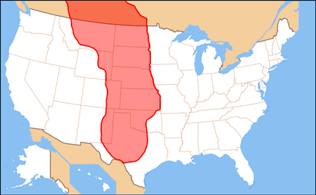
CRS: Federal Involvement in Flood Response and Flood Infrastructure Repair: Storm Sandy Recovery. / : Nicole T. Carter. Specialist in Natural Resources Policy. October 31, 2012. - 12 s.
'Although the storm was not notable for its wind intensity, Sandy’s significant size, its unusually low atmospheric pressure, and the astronomic high tide combined with other weather systems to amplify flooding consequences and economic and transportation disruptions. With events like Storm Sandy, common questions for Congress include: Which federal programs can assist with flood-fighting? Which federal programs can assist with repairing damaged dunes, levees, and other flood protection? What are the policy and funding issues that may arise during recovery? While state and local entities have significant flood-related responsi-bilities, federal resources are called in as these entities are overwhelmed and as presidential disasters are declared. Several agencies, including the Federal Emergency Management Agency (FEMA) and the U.S. Army Corps of Engineers, have authorities to respond to flood emergencies and to assist with recovery efforts.'
CRS: Water Resource Issues in the 113th Congress. / : Betsy A. Cody et al. January 31, 2013. - 14 s.
'Federal Water Resource Agencies
Most of the large dams and water diversion structures in the United States were built by, or with the assistance of, Reclamation or the Corps. Historically, Reclamation projects were designed principally to provide reliable supplies of water for irrigation and some municipal and industrial uses. Corps projects were planned principally to improve navigation and reduce flood damages, with power generation, water supply, and recreation being incidental benefits. Reclamation currently manages more than 600 dams and reservoirs in 17 western states, providing water to approximately 10 million acres of farmland and 31 million people, as well as 58 power plants capable of producing 40 billion kilowatt-hours of electricity annually (enough for approximately 3.5 million homes). The Corps operates nationwide, and its activities are diverse. The Corps has constructed thousands of flood damage reduction and navigation projects throughout the country, including nearly 12,000 miles of commercially active waterways, nearly 1,000 harbors, and 600 dam and reservoir projects (with 75 hydroelectric plants generating 68 billion kilowatt-hours annually). Additionally, the Corps constructed, usually with nonfederal participation, roughly 9,000 miles of the estimated 100,000 miles of the nation’s levees, but only maintains 900 miles. The remaining levees are operated by nonfederal entities, often local governments or special districts.'
Wasting Our Waterways 2012: Toxic Industrial Pollution and the Unfulfilled Promise of the Clean Water Act. / Rob Kerth, Shelley Vinyard, Environment America Research & Policy Center. 2012. - 53 s.
Evaluating Cumulative Ecosystem: Response to Restoration Projects in the Lower Columbia River and Estuary, 2009. / Prepared by: Pacific Northwest National Laboratory, National Marine Fisheries Service, Columbia River Estuary Study Taskforce, University of Washington. October 2010. - 150 s.
Geohydrology of the Shallow Aquifer System, Naval Weapons Station Yorktown, Yorktown, Virginia. / A.R. Brockman, D.L. Nelms, G.E. Harlow, Jr., and J.J. Gildea. U.S. Geological Survey, Water-Resources Investigations Report 97-4188, 1997. - 66 s.
- http://pubs.usgs.gov/wri/1997/4188/report.pdf
'In the conceptual ground-water-flow system at the Station, ground water flows downward from the Columbia aquifer in the recharge areas to and through the Cornwallis Cave and (or) Yorktown-Eastover aquifers to the discharge areas (seeps, springs, streams, and estuaries). A ground-water divide trends west to east across the south central Station in each of the lower two shallow aquifers. Ground-water flow generally is either north toward the York River estuary or south toward the James River estuary on opposite sides of the divide'.
Greenhouse effect, sea level rise, and coastal wetlands. / : James G Titus et al.
- Washington, D.C. : U.S. Environmental Protection Agency, 1988. - 168 s.
- http://archive.org/details/greenhouseeffect00titu
'Increasing atmospheric concentrations of carbon dioxide and other gases released by human activities are generally expected to warm the earth a few degrees (C) in the next century by a mechanism commonly known as the "greenhouse effect." Such a warming could raise sea level by expanding ocean water, melting mountain glaciers, and eventually causing polar ice sheets to slide into the oceans. Unfortunately, it is not yet possible to accurately predict future sea level. Estimates for the year 2025 range from five to fifteen inches above current sea level, while estimates of the rise by 2100 range from two to seven feet. Although the timing and magnitude of future sea level rise is uncertain, there is an emerging scientific consensus that a significant rise is likely.
To further society's understanding of how to rationally respond to the possibility of a substantial rise in sea level, EPA has undertaken assessments of the impacts of sea level rise on economic development, beach erosion control strategies, salinity of estuaries and aquifers, and coastal drainage and sewage systems. Those studies have generally found that even a one-foot rise in sea level has important implications for the planning and design of coastal facilities. This report examines the potential impacts of sea level rise on coastal wetlands in the United States. Coastal marshes and swamps are generally within a few feet of sea level, and hence could be lost if sea level rises significantly. Although new wetlands could form where new areas are flooded, this cannot happen where the land adjacent to today's wetlands is developed and protected from the rising sea. Once built, neighborhoods can be expected to last a century or longer. Therefore, today's coastal development could limit the ability of coastal wetlands to survive sea level rise in the next century.'
Kitsap halvøen.
Bjerge: Appalachian bjergkæden, herunder Swarthmore Mountain, Mountaynes Apalatsi eller Apalache Cheyenne Mountain. Lookout Mountain. Rocky Mountain. Sierra Nevada bjergkæden. Mount Weather. Yucca Mountain.
US. Congress. House. Committee on Appropriations. Subcommittee on Public Works.: Public works appropriations for 1969, for water and power resources development and the Atomic Energy Commission. - Washington,: Govt. Print. Off., 1968.- 1580 s.
'pt.1. Atlantic-Pacific Interoceanic Canal Study Commission; Civil Functions, Army; Delaware River Basin Commission; Panama Canal. -pt.2. Alaska Power Administration; Bonneville Power Administration; Bureau of Reclamation; Federal Water Pollution Control Administration; Southeastern Power Administration; Southwestern Power Administration; Tennessee Valley Authority; Water Resources Council'.
- http://www.archive.org/details/publicworksappro01unit
The Great Plains is a vast expanse of glasslands stretching from the Rocky Mountains to the Missouri River and from the Rio Grande to the coniferous forests of Canada—an area more than eighteen hundred miles from north to south and more than five hundred miles from east to west. The Great Plains region includes all or parts of Texas, New Mexico, Oklahoma, Kansas, Colorado, Nebraska, Wyoming, South Dakota, North Dakota, Montana, Alberta, Saskatchewan, and Manitoba. The region, once labeled "the Great American Desert (See: Excerpt From "The Plow That Broke The Plains": Producer: Pare Lorenz, 1936.
- http://www.archive.org/details/PlowThatBrokethePlains1),"
is now more often called the "heart-land," or, sometimes, "the breadbasket of the world." /
De store sletter eller prærierne er et stort område med landbrugsjord som strækker sig fra Rocky Mountains til Missouri-floden og fra Rio Grande til nåleskove i Canada, et område på mere end 2800 km fra nord til syd og mere end fem hundrede kilometer fra øst til vest.
Prærierne omfatter hele eller dele af Texas, New Mexico, Oklahoma, Kansas, Colorado, Nebraska, Wyoming, South Dakota, North Dakota, Montana, Alberta, Saskatchewan og Manitoba. Regionen - en gang betitlet "The Great American Desert (se stumfilmen "The Plow That Broke The Plains": Producer: Pare Lorenz, 1936. - http://www.archive.org/details/PlowThatBrokethePlains1,")
kaldes nu oftere "Heartland" eller nogle gange "verdens brødkurv ."
Encyclopedia of the Great Plains. / : David J. Wishart, Editor University of Nebraska–Lincoln
- http://plainshumanities.unl.edu/encyclopedia/
The northern Great Plains of Canada and the United States cover thousands of square miles. This true-color Aqua MODIS image from May 3, 2005, shows a portion of the Great Plains covering Saskatchewan, Manitoba, and a small slice of Ontario, Canada, and Montana, North Dakota, Minnesota, Wyoming, and South Dakota in the United States. Scattered across the region are thousands of lakes ranging in color from deep blue-green and black to milky blue, tan, and even white. In the northern part of the image, many of the lakes are white because their surfaces are still frozen from the cold winter, and spring temperatures have not risen enough to thaw them completely. The largest lake in the scene, Lake Winnipeg, shows the greatest amount of surface ice, while the clear water at its northern end shows swirls of milky tan sediment. To the east, Lake Manitoba is ice free, but also shows swirls of cloudy sediment in its waters. - http://archive.org/details/VE-IMG-8088
Skov: Black Hills National Forest. Extent of Off-Site Uranium Contamination from Custer National Forest and Black Hills National Forest Abandoned Uranium Mine Sites, North Cave Hills Final Report. South Dakota School of Mines and Technology. 2007. - 217 s. - http://uranium.sdsmt.edu/Literature.htm

USA har 71.862 tons atomaffald, som er midlertidigt oplagret i mere end 30 stater, ifølge data indsamlet af AP.
GSN: Japanese Crisis Highlights U.S. Atomic Waste Safety Problem. Thursday, March 24, 2011.
Our western empire, or, The new West beyond the Mississippi [microfilm] : containing the fullest and most complete description, from official and other authentic sources, of the geography, geology and natural history (with abundant incidents and adventures), the climate, soil, agriculture, the mineral and mining products, the crops, and herds and flocks, the social condition, educational and religious progress, and future prospects of the whole region lying between the Mississippi and the Pacific Ocean : to which is added the various routes, and prices of passage and transportation for emigrants thither, the laws, regulations and provisions for obtaining lands from the national or state governments or railroads, counsel as to locations and procuring lands, crops most profitable for culture, mining operations, and the latest processes for the reduction of gold and silver, the exercise of trades or professions, and detailed descriptions of each state and territory, with full information concerning Manitoba, British Colombia, and those regions in the Atlantic States adapted to settlement, by those who do not wish to go west, and statistics of crops, areas, rainfall, etc. (1881). - http://www.archive.org/details/cihm_24348

Ørkenområder: Chihuahuan Desert ; Great Basin Desert.

Se også: Amerikanske lokalstater. Nordamerikas natur ; Stillehavets natur.
Se tillige: Afghansk natur ; Albansk natur ; Algerisk natur ; Andorras natur ; Angolas natur ; Antigua & Barbudas natur ; Argentinsk natur ; Armensk natur ; Aserbajdsjans natur ; Australsk natur ; Bahamas natur ; Bahrains natur ; Bangladesh natur ; Barbados natur ; Belgisk natur ; Belizesk natur ; Benins natur ; Bhutans natur ; Boliviansk natur ; Bosnien-Hercegovinas natur ; Botswanas natur ; Brasiliens natur ; Brunei Darussalams natur ; Bulgarsk natur ; Burkina Fasos natur ; Burundis natur ; Canadisk natur ; Cambodjansk natur ; Camerouns natur ; Centralafrikansk natur ; Chilensk natur ; Colombiansk natur ; Comorernes natur ; Congolesisk natur ; Costa Ricas natur ; Cubansk natur ; Cypriotisk natur ; Dansk natur ; Djiboutisk natur ; Dominicansk natur ; Dominicas natur ; Ecuadoriansk natur ; Engelsk natur ; Egyptisk natur ; El Salvadoransk natur ; Elfenbenskystens natur ; Eritreas natur ; Estlands natur ; Etiopisk natur ; Fijis natur ; Filippinsk natur ; Finsk natur ; De forenede arabiske Emiraters natur ; Fransk natur ; Færøsk natur ; Gabons natur ; Gambiansk natur ; Georgiansk natur ; Ghanas natur ; Grenadas natur ; Græsk natur ; Grønlandsk natur ; Guatemalas natur ; Guineas natur ; Guinea-Bissaus natur ; Guyansk natur ; Haitiansk natur ; Hollansk natur ; Honduras natur ; Hvideruslands natur ; Indisk natur ; Indonesisk natur ; Irakisk natur ; Iransk natur ; Islandsk natur ; Irsk natur ; Israelsk natur ; Italiensk natur ; Jamaicas natur ; Japansk natur ; Jordans natur ; Kap Verdisk natur ; Kasakhstanisk natur ; Kenyansk natur ; Kinesisk natur ; Kirgisistans natur ; Kiribatis natur ; Kosovos natur ; Kroatiens natur ; Kuwais natur ; Laotisk natur ; Lesothisk natur ; Letlands natur ; Libanesisk natur ; Liberiansk natur ; Libysk natur ; Liechtensteins natur ; Litauens natur ; Luxembourgs natur ; Madagascars natur ; Makedonsk natur ; Malawis natur ; Malaysias natur ; Maldiviensk natur ; Malis natur ; Maltesisk natur ; Marokkansk natur ; Marshalløernes natur ; Mauretaniens natur ; Mauritius natur ; Mexicansk natur ; Mikronesisk natur ; Moldovisk natur ; Monacos natur ; Mongoliets natur ; Montenegros natur ; Mozambiques natur ; Myanmars natur ; Namibias natur ; Naurus natur ; Nepals natur ; New Zealandsk natur ; Nicaraguansk natur ; Nigers natur ; Nigerias natur ; Norsk natur ; Nordkoreansk natur ; Omans natur ; Pakistansk natur ; Palaus natur ; Palæstinas natur ; Panamas natur ; Papua Ny Guineansk natur ; Paraguays natur ; Peruviansk natur ; Polsk natur ; Portugisisk natur ; Qatars natur ; Rumænsk natur ; Russisk natur ; Rwandas natur ; Salomonøernes natur ; Samoas natur ; San Marinos natur ; São Tomé & Principles natur ; Saudi-Arabisk natur ; Schweizisk natur ; Senegals natur ; Serbisk natur ; Seychellernes natur ; Sierra Leones natur ; Singapores natur ; Skotsk natur ; Slovakiets natur ; Sloveniens natur ; Somalisk natur ; Spansk natur ; Sri Lankas natur ; St. Kitts & Nevis natur ; St. Lucias natur ; St. Vincent og Grenadinernes natur ; Sudanesisk natur ; Surinams natur ; Svensk natur ; Swazilands natur ; Sydafrikansk natur ; Sydkoreansk natur ; Syrisk natur ; Tadsjikistans natur ; Taiwanesisk natur ; Tanzanias natur ; Tchads natur ; Thailandsk natur ; Tjekkisk natur ; Togos natur ; Tongas natur ; Trinidad & Tobagos natur ; Tunesisk natur ; Turkmenistans natur ; Tuvalus natur ; Tyrksk natur ; Tysk natur ; Ugandas natur ; Ukrainsk natur ; Ungarnsk natur ; Uruguays natur ; Usbekistans natur ; Vanuatus natur ; Venezuelas natur ; Vietnamesisk natur ; Yemens natur ; Zambias natur ; Zimbabwes natur ; Ækvatorial Guineas natur ; Østrisk natur ; Østtimors natur.

Send kommentar, email eller søg i Fredsakademiet.dk
Locations of visitors to this page