- Geografi ; natur ; klima ; geologi ; demografi ; historie ; krige ;
kultur ; kunst ; film
; musik ; politik ;
politiske partier ; forsvar ; fredsbevægelser ; religion ; sociale
forhold ; uddannelse ; økonomi og våbenhandel.
- Geography, nature and climate, demographics, history, wars,
culture, film, music, politics, defense, peace movements, religion,
social issues, education, economy and arms trade.
- Géographie, la nature, la démographie, histoire,
la culture, la politique, la défense, les mouvements
pacifistes, la religion, les questions sociales,
l'éducation, économie.
- Geografía, naturaleza, demografía, historia,
cultura, política, defensa, movimientos por la paz, la
religión, las cuestiones sociales, la educación, la
economía
- Geographie, Natur, Demographie, Geschichte, Kultur, Politik,
Verteidigung, Friedensbewegungen, Religion, Soziales, Bildung,
Wirtschaft.
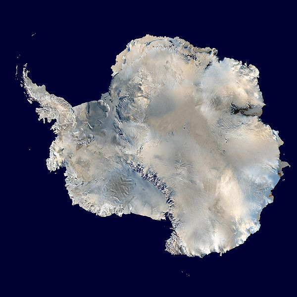
Antarktis / Antarctica / Antarctique /
Antártida / Antarktika
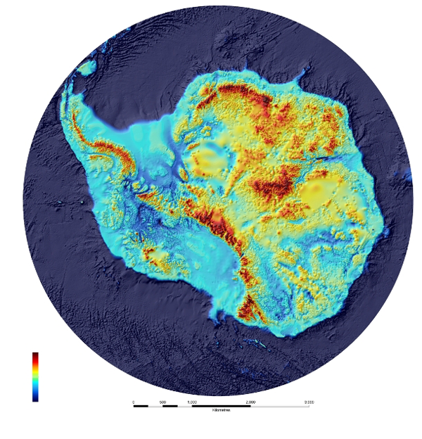
- Geografi: Græsk: Oprindelig betydning: Modsat
bjørnen, stjernebilledet Lille bjørn med
Nordstjernen. Kontinentet, landet,
øerne og havet omkring
Sydpolen: Det sydlige ishav, Sydhavet eller Sydpolarhavet.
Antarktis er en del af jordens kryosfære (isdække), eksempelvis
Larsen-ismassivet.
- Greek: Original meaning: Opposite the bear, the constellation
Little Bear with the North Star. Geography: Continent, the land,
islands and the sea around the South Pole: the southern Arctic
Ocean, the Southern Ocean or south polar waters. Antarctica is part
of the earth's cryosphere (ice cover), for example, the Larsen ice
mass or the Larsen ice shelter
- Climate and Melting Variability in Antarctica. I: Eos,
Vol. 91, No. 1, 5 January 2010.
- Larsen-ismassivet er brækket – for tredje
gang!: Onsdag kl. 10.45 meddelte britiske klimaforskere, at et
isbjerg næsten så stort som Sjælland er
brækket af ved Antarktis. Det er tredje gang, et sådant
sammenbrud rammer den berømte Larsen-ishylde mod syd. Ingen
kan vide, om det skyldes global opvarmning – frygten er, at
der nu er sat fart på en forstærket afsmeltning af den
antarktiske is. / : Jørgen Steen Nielsen. I:
Information, 13. juli 2017.
- Geographic Names of the Antarctic 2nd Edition. / : Fred G.
Alberts. United States Board on Geographic Names, 1995.
-
https://archive.org/details/GeographicNamesOfTheAntarctic2ndEdition.
'Included in this geographic area, the Antarctic region, are the
off-lying South Shetland Islands, the South Orkney Islands, the
South Sandwich Islands, South Georgia, Bouvetbya, Heard Island, and
the Balleny Islands.'
- Satellite Image Atlas of Glaciers of the World, 2010.
- http://pubs.usgs.gov/pp/p1386/
U.S. Geological Survey Professional Paper 1386, Satellite Image
Atlas of Glaciers of the World, contains 11 chapters designated by
the letters A through K. Chapter A provides a comprehensive, yet
concise, review of the "State of the Earth's Cryosphere at the
Beginning of the 21st Century: Glaciers, Global Snow Cover,
Floating Ice, and Permafrost and Periglacial Environments," and a
"Map/Poster of the Earth's Dynamic Cryosphere," and a set of eight
"Supplemental Cryosphere Notes" about the Earth's Dynamic
Cryosphere and the Earth System. The next 10 chapters, B through K,
are arranged geographically and present glaciological information
from Landsat and other sources of historic and modern data on each
of the geographic areas. Chapter B covers Antarctica; Chapter C,
Greenland; Chapter D, Iceland; Chapter E, Continental Europe
(except for the European part of the former Soviet Union),
including the Alps, the Pyrenees, Norway, Sweden, Svalbard
(Norway), and Jan Mayen (Norway); Chapter F, Asia, including the
European part of the former Soviet Union, China, Afghanistan,
Pakistan, India, Nepal, and Bhutan; Chapter G, Turkey, Iran, and
Africa; Chapter H, Irian Jaya (Indonesia) and New Zealand; Chapter
I, South America; Chapter J, North America (excluding Alaska); and
Chapter K, Alaska. Chapters A–D each include map plates.
- Grèce: le sens original: En face de l'ours, l'ours
constellation peu avec l'étoile du Nord. Géographie:
Continent, la terre, les îles et la mer autour du pôle
Sud: le sud de l'océan Arctique, l'océan Austral au
sud ou dans les eaux polaires.
- Griego: significado original: Frente al oso, el oso
pequeño con la constelación de la estrella del norte.
Geografía: Continente, la tierra, las islas y el mar en
torno al Polo Sur: el sur del Océano Ártico, el
Océano Antártico al sur o aguas polares.
- Griechischen: Original Bedeutung: Gegen-über der Bär,
das Sternbild Kleiner Bär mit der Nordstern oder Polarstern.
Geographie: Kontinent, das Land, Inseln und das Meer rund um den
Südpol: der südliche Eismeer, das Süd-polarmeer oder
Süden polaren Gewässern.
- Natur, klima.
Biodiversitet. Fauna og flora: Fisk.
Fugle.
Koralrev.
Vådområder.
Nature, climate. Flora and fauna: Botanical gardens. Fish. Birds.
Coral reefs. Wetlands
Flore et faune: Poissons. Oiseaux. Les récifs coralliens.
Les zones humides.
Flora y fauna: Fish. Pájaros. Los arrecifes de coral. Los
humedales.
Natur, Klima. Flora und Fauna: Botanische Gärten. Fisch.
Vögeln. Korallenriffe. Feuchtgebiet, Feuchtbiotop.
- International Network of Basin Organizations / Det
internationale netværk af flodbassin organisationer.
- http://www.inbo-news.org/spip.php?sommaire⟨=en:
- Tekst:
- Handbook of Australian, New Zealand and Antarctic Birds
(HANZAB) I-VII.
- http://www.birdsaustralia.com.au/
- Pelembe, T. and Cooper, G.eds (2011). UK Overseas Territories
and Crown Dependencies: 2011 Biodiversity Snapshot. Peterborough,
UK, Joint Nature Conservation Committee.
- http://jncc.defra.gov.uk/page-5759
-
http://jncc.defra.gov.uk/PDF/ot_biodiversity2011_complete.pdf
- De Broyer C., Koubbi P., Griffi ths H.J., Raymond B., Udekem
d’Acoz C. d’, Van de Putte A.P., Danis B., David B.,
Grant S., Gutt J., Held C., Hosie G., Huettmann F., Post A.,
Ropert-Coudert Y. (eds.), 2014. Biogeographic Atlas of the Southern Ocean.
Scientific Committee on Antarctic Research, Cambridge, XII + 498
pp.

- http://share.biodiversity.aq/Atlas/example_BASO_web.pdf
- Geologi og
jordbundsforhold: Bjerge,
vulkaner, jordskælv og ørkenområder:
Geology: Mountains, volcanoes, earthquakes and desert areas
Géologie: Montagnes, volcans, tremblements de terre et les
zones désertiques
Geología: Montañas, volcanes, terremotos y zonas
desérticas
Geologie: Berge, Vulkane, Erdbeben und Wüstengebiete
- World Database on Protected
Areas: Beskyttede områder og
nationalparker.
- Antarctic Specially Protected Areas
Status of Antarctic Specially Protected Area and Antarctic
Specially Managed Area Management Plans (Updated 2013)
- http://www.ats.aq/documents/ATCM36/WW/atcm36_ww005_e.pdf
eksempelvis: Management Plan for Antarctic Specially Protected Area
No. 125
FILDES PENINSULA, KING GEORGE ISLAND (25 DE MAYO)
(Fossil Hill, Holz Stream (Madera Stream), Glacier Dome
Bellingshausen (Collins Glacier), Halfthree Point, Suffield Point,
Fossil Point, Gradzinski Cove and Skua Cove)
Introduction
'An area of 1.8 km2 (444,79 acres) in the Fildes Peninsula, King
George Island (25 de Mayo), South Shetland Islands archipelago, was
proposed as a SPA (Special Protected Area) by Chile four decades
ago on the grounds of its uniqueness and paleontological richness.
The area was officially designated SPA No 12 at ATCM IV (Santiago,
1966). After 42 years under different statuses (SPA, SSSI and
ASPA), and numerous scientific studies, it is necessary to review
whether these areas can be considered an ASPA, whether or not they
can be defined as “an area designated to protect outstanding
environmental, scientific, historic, aesthetic or wilderness
values”.'
- http://www.ats.aq/documents/recatt/Att424_e.pdf
- Griffiths, H.J., et al.,Quantifying Antarctic marine
biodiversity: The SCAR-MarBIN dataportal. Deep-Sea Research
II(2010),doi:10.1016/j.dsr2.2010.10.008
'The documentation and analysis of broad-scalebiological diversity
requires modern databases.Here we describethe SCAR-Marine
Biodiversity Information Network (SCAR-MarBIN) and demonstrate its
value with a preliminary analysis of geographic patterns in species
richness for a variety of marine taxa. SCAR-MarBIN is a webportal
(www.scarmarbin.be) that compiles and manages existing and new
information on Antarctic marine biodiversity; it currently links
over140 datasets comprising over one million records. The portal is
homet ot he Registry of Antarctic Marine Species(RAMS), an
authoritative taxonomic list of marine species occurring in
Antarctica.'
Ingels J, Vanreusel A, De Broyer C, Martin, P, De Ridder C, Dubois
P, Dauby P, David B, d’ Udekem d’Acoz C, Robert H, ,
Catarino AI, Pierrat B, Havermans C, Pasotti F, Guilini K, Hauquier
F. BIANZO II: Biodiversity of three representative groups of the
Antarctic Zoobenthos - Coping with Change. Final Report. Brussels :
Belgian Science Policy 2011 – 133 p. (Research Programme
Science for a Sustainable Development, SSD).
-
http://www.belspo.be/belspo/ssd/science/Reports/Final%20Report%20BIANZOII%20ML.pdf
The biodiversity and ecology of Antarctic lakes: models for
evolution Johanna Laybourn-Parry and David A. Pearce. Phil. Trans.
R. Soc. B (2007) 362, 2273–2289 doi:10.1098/rstb.2006.1945.
Published online 21 May 2007.
-
http://rstb.royalsocietypublishing.org/content/royptb/362/1488/2273.full.pdf
- Cold Regions Bibliography.
- http://www.loc.gov/rr/frd/coldregions/
Lake Vostok.
- http://www.archive.org/details/SVS-996.
Warming Climate May Release Vast Amounts Of Carbon From
Long-Frozen Arctic Soils. / : Countercurrents.org, 27 April
2015.
-
- Antarktis er, ifølge
Antarktis-traktaten, et afrustet ingenmandsland. Der er ingen fastboende
befolkning, 2011.
- Antarctica is, according to the Antarctic Treaty, a disarmed no
man's land. There is no resident population, 2011.
- L'Antarctique est, selon le Traité sur l'Antarctique,
une terre pas désarmé l'homme. Il n'existe pas de
population résidente, 2011.
- La Antártida es, de acuerdo con el Tratado
Antártico, un desarmado tierra de nadie. No hay una
población residente de 2011.
- Die Antarktis ist nach dem Antarktis-Vertrag, entwaffnet ein
Niemandsland. Es gibt keine Wohnbevölkerung, 2011.
- Historie:
- Se: Geographic names of Antarctica
- https://archive.org/details/geographicnameso00bert
- Politik:
International politik vedrørende Antarktis i perioden fra anden verdenskrig til og med den første
del af den kolde krig er beskrevet i
opslaget om Antarktis-traktaten.
- Politics: International policy on Antarctica during the period
from WWII through the early part of the cold war is described in
the entry on the Antarctic Treaty.
- Politique: La politique internationale sur l'Antarctique au
cours de la période allant de la Seconde Guerre mondiale
jusqu'au début de la guerre froide est décrite dans
l'article sur le Traité sur l'Antarctique.
- Política: La política internacional en la
Antártida durante el período de la Segunda Guerra
Mundial a través de la primera parte de la guerra
fría se describe en la entrada en el Tratado
Antártico.
- Politik: Internationale Politik in der Antarktis in der Zeit
vom Zweiten Weltkrieg über die ersten Monate des Kalten
Krieges in der Eintrag auf der Antarktis-Vertrag beschrieben.
- Naturresourcer: Jern, kobber, mangan, molybdæn, nikkel,
olie og naturgas, sølv, titanium uran.
- Se også: Arktisk ;
Falklandsøerne ; Den geografiske sydpol ; den magnetiske
sydpol ; the Scientific Committee on Antarctic Research.
- See also: The geographic South Pole, the magnetic south pole,
the Scientific Committee on Antarctic Research.
-
-
The Peace Palace Library: Antactica.
Larsen, Henrik: Et russisk bor prikkede hul i indlandsisen.
I: Politiken, 02/12/2012.
Send
kommentar, email eller søg i
Fredsakademiet.dk